
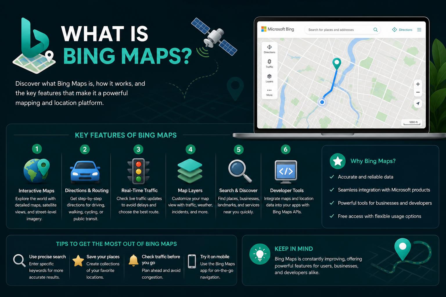
- Bing Maps integrates comprehensive map views, real-time traffic, and global business data
- The platform supports developers and enterprises through APIs and migration to Azure Maps
- Coverage spans North America, Europe, Asia, and more, powered by TomTom and OpenStreetMap
- Features like dynamic labels and venue maps enhance user experience for personal and business needs
When you start searching for “what is Bing Maps,” you’re probably expecting a simple navigation tool or an alternative to Google. But there’s a whole lot more to Bing Maps than meets the eye. This article will take you on a thorough journey into everything you need to know about Bing Maps today—covering its history, features, developer options, coverage, and how it stands out in the world of online mapping.
If you’re looking for reliable map services for personal, business, or development needs, Bing Maps has quietly evolved into a comprehensive web mapping platform with a broad feature set and impressive global reach. Whether you’re a developer seeking API access, a business owner exploring integration options, or a user curious about all the bells and whistles, this guide is for you.
Understanding Bing Maps: An Overview
Bing Maps is Microsoft’s web-based mapping service, seamlessly connecting users to global road maps, satellite imagery, aerial photos, and a host of navigation features. Since its launch in 2005 (originally as MSN Virtual Earth), Bing Maps has continuously evolved, both in terms of original technology and through partnerships with data providers like TomTom and OpenStreetMap. As part of the Bing ecosystem, it competes with Google Maps but offers its own unique blend of features, integrations, and developer capabilities.
The Evolution: From Virtual Earth to Bing Maps
The roots of Bing Maps reach back to July 2005, when Microsoft introduced MSN Virtual Earth for beta testing. The platform’s initial draw was its advanced aerial imagery, distinguishing itself from earlier Microsoft mapping technologies like MapPoint and TerraServer. However, this early version lacked what are now staple features—like bird’s-eye view and 3D maps.
By December 2005, Virtual Earth transformed into Windows Live Local, boasting features like integration with local search indexes and technology sourced from Pictometry International. The ability to view in 3D arrived a year later, leading to the “Live Search Maps” branding, closely integrated with Microsoft’s Live Search services.
On June 3, 2009, Microsoft officially rebranded the mapping service as Bing Maps, while the underlying platform became known as Bing Maps for Enterprise. Since then, Bing Maps has regularly expanded its features and coverage, including the addition of OpenStreetMap layers in 2010, and the transition to TomTom as its primary data provider in 2020.
Core Features in Bing Maps
Bing Maps brings a diverse toolkit for exploring, navigating, and visualizing the world. Below are its current and legacy feature highlights, each enhancing user experience in unique ways.
- Multiple Map Views: Bing Maps supports Road View (the vector standard), Aerial View (satellite imagery with overlays), and, until recently, Bird’s-eye and Streetside imagery (both retired in 2025).
- 3D Maps: Experience urban landscapes and global terrains with 3D perspectives. Buildings are textured through aerial photo composites. This feature required a browser plug-in and was compatible with Xbox or other game controllers for navigation within Windows OS.
- Directions and Route Planning: The platform makes it easy to get driving, walking, cycling, and public transit directions. Coverage of public transit has greatly expanded from its initial U.S. cities to include global locations like Spain, Germany, Italy, and many more.
- Local Business Search: Users can search for restaurants, hotels, events, and businesses—directly on the map, supported by an ever-expanding range of local directory integrations.
- Venue Maps: Get detailed layouts for over 5,300 venues worldwide, with categories including airports, amusement parks, malls, museums, and sports arenas.
- Traffic and ClearFlow: Bing Maps offers real-time traffic data on major highways and city streets, using a color-coded system and an AI-powered feature called ClearFlow to suggest smarter alternative routes and anticipate congestion patterns.
- Map Apps: Previously, Bing Map Apps offered both Microsoft and third-party tools for use directly in the browser, including features for parking, taxi fare estimation, event discovery, weather updates, and even integrating Facebook friends’ locations. Many of these were accessible only through the Silverlight version, now retired.
- User Contributions: Users can add “user contributed” records for businesses, landmarks, and other locations—enriching the dataset for community benefit.
- Sharing and Embedding: Easily send maps via shareable links or embed interactive maps in your own web pages.
Bing Maps Imagery: Road, Aerial, and More
Bing Maps provides five main map views: Road, Aerial, Bird’s-eye (retired), Streetside (retired), and 3D. Each serves a different navigational and visual purpose:
- Road View: The default style showcasing clear vector graphics for roads, buildings, and terrain. Depending on region, data might be sourced from providers ranging from TomTom to regional mapping agencies like Ordnance Survey in the UK and Collins Bartholomew in London.
- Aerial View: Offers high-resolution satellite imagery, overlaying roads and major POIs for simple identification. Since late 2010, OpenStreetMap editors have been able to use Bing’s aerial imagery as a mapping background for their own projects (OpenStreetMap).
- Bird’s-eye View: Previously provided 45-degree angle aerial photographs, offering unique depth perspectives and clearer visuals on buildings and signs. This feature, along with Streetside, was officially discontinued in 2025—but its impact lives on as a legacy highlight of Bing Maps’ visual capabilities.
- Streetside: Bing’s answer to Google Street View, giving users panoramic street-level imagery for select major metro areas across the U.S., Canada, and Europe. Streetside became unavailable from October 2025 onward.
- 3D View: Users could install a special plug-in to navigate through detailed 3D urban environments. Many major U.S. and European cities, as well as select landmarks worldwide, were modelled in photorealistic detail. Newer 3D imagery has been added since 2014, enriching the virtual globetrotting experience.
Bing Maps stands out with its multi-modal routing capabilities:
- Driving Directions: Enter multiple destinations and get turn-by-turn routes optimized for current traffic. Bing’s data ingestion from real-time sensors means route suggestions are reliable, often leveraging the ClearFlow technology for congestion anticipation.
- Transit Navigation: Since 2010, Bing Maps has included bus, train, and subway directions—initially only in select North American cities but rapidly growing to offer transit coverage in Europe, Latin America, and Asia.
- Walking and Cycling: Get routes specifically calculated for pedestrians or cyclists—complete with terrain cautions and time estimates, where regional data is available.
Real-Time Traffic and ClearFlow
Traffic conditions are a critical feature for any modern mapping service, and Bing Maps delivers using both data and AI: the ClearFlow tool gives real-time traffic updates for 72 major U.S. cities. It uses a straightforward color code (black for gridlock, red for heavy, down to green for clear), combining data from sensors, weather, and event information to help drivers avoid jams. ClearFlow calculates not only main highway delays, but also secondary street patterns, giving users suggestions for the fastest, smoothest routes at any given time.
Business Directory and Search Capabilities
Bing Maps integrates a robust local business search function. Whether you’re looking for a restaurant, a hotel, local attractions, or even user-generated places, search results appear both on the map and in a side panel, usually accompanied by addresses, contact info, and—when available—a short Wikipedia-powered description. Dynamic search labels and local directories make category-based exploration simple.
Sharing, Customization, and Embedded Maps
Bing Maps offers easy map sharing and embedding: click the email or share icon to get a link that anyone can open to see your exact map view, or grab HTML code to embed a dynamic, interactive Bing Map into your blog or website. These options are perfect for businesses, travel bloggers, or event planners who want to point others to a specific location or provide rich, interactive content within their sites.
Bing Maps Venue Maps: Mapping Indoor Spaces
Venue Maps give users detailed layouts for over 5,300 global venues—from airports and shopping malls to zoos and amusement parks. Categories include:
- Airports
- Museums
- Hospitals
- Convention Centers
- Shopping Centers
- Stadiums
- Universities
For travelers, event-goers, and visitors to new cities, these indoor maps help with efficient navigation through large, unfamiliar spaces.
Bing Map Apps: Extended Functionality (Now Retired)
One of the more innovative aspects of Bing Maps was the Map Apps library, especially in the era when the Silverlight version was active. Map Apps included both Microsoft and third-party-developed tools that expanded Bing Maps’ utility. Some notable examples included:
- ParkingFinder: Real-time parking information and pricing for major cities.
- Taxi Fare Calculator: Quick fare estimates based on your chosen route.
- Weather and Event Apps: In-map overlays showing local weather, upcoming activities, and news.
- Travel Webcams: Access live feeds from global points of interest.
- Random Location: Instantly jump to a random spot on the globe—great for virtual exploring!
Developers wanting to contribute or extend Bing Maps features could find source code on Microsoft Developer Network, gaining insight into creating custom overlays, data integrations, and interactive tools for both consumer and enterprise use cases.
Developer and Enterprise Options
Bing Maps is not just for end-users; it’s a major platform for developers and enterprises, supplying robust APIs and resources.
Bing Maps Key: To access the myriad web services and developer APIs, you’ll need a Bing Maps Key. This is simple to obtain through the Bing Maps Dev Center. Sign in, create a new application, select your application and key type, and get your unique API credential. You can use this for REST services, JavaScript integration, and more. Usage transactions are logged for each key, and usage reports are accessible via the Dev Center dashboard.
Transition to Azure Maps: It’s important to note that Bing Maps for Enterprise is being deprecated; regular users can continue using these services up to June 30, 2025, while paid enterprise customers have access till 2028. Microsoft is directing new and current business users toward Azure Maps, its latest geospatial platform which offers similar and expanded functionality.
For custom WebGIS solutions or sophisticated business applications, authorized Bing Maps resellers like WIGeoGIS can assist in consulting and licensing, data integration, and solution development.
Global Coverage: Where Can You Use Bing Maps?
Bing Maps offers extensive international coverage, leveraging geodata providers like TomTom, Navteq (now HERE), and OpenStreetMap to ensure global accuracy. The breadth and depth of map data vary by region, but road maps, business directories, and POIs (points of interest) are available across North America, Europe, most of Asia, South America, Australia, and parts of Africa.
Detailed tables of Bing Maps’ global reach highlight these distinctions:
- Major coverage (full detail, business search, POIs): United States, Canada, United Kingdom, much of Western Europe (France, Germany, Italy, Spain, Netherlands, and more), Australia, India, Japan, Brazil, and select others.
- Limited detail or POIs only: Numerous territories in Africa, Southeast Asia, South America, and Oceania still receive basic mapping and main road information, though finer venue and local business data may be sparse.
- Venue maps: Over 5,000 large, high-traffic venues globally have internal map layouts, particularly airports, shopping complexes, and sports stadiums.
The ongoing partnership with DigitalGlobe enabled Bing Maps to offer ultra-high-resolution orthophotos for the contiguous United States and Western Europe, beginning with coverage of Augusta, San Diego, and Tampa, and continuously expanding through regular monthly updates (often over 10TB of new imagery released at a time).
Technology, Compatibility, and System Requirements
Bing Maps is web-based, optimized for modern browsers like Edge, Chrome, Firefox, and Safari. While a previous Silverlight-powered version with enhanced dynamic UI/UX is now retired, the standard AJAX version remains robust and accessible without the need for plug-ins.
For users needing 3D map features, historical plug-ins required:
- Windows XP with Service Pack 2 or higher, or Windows Vista/7 systems
- At least 250 MB hard disk space
- 1 GHz processor (2.8 GHz recommended)
- 256 MB RAM (1 GB recommended)
- A 32 MB DirectX 9-compatible video card (256 MB recommended)
- Broadband internet
Browser support included Internet Explorer 6+, Firefox 3+, and Safari 3.1+, with Opera working but with limited features. Today, Bing Maps is designed for mainstream compatibility and doesn’t require extra software—just an up-to-date browser.
Map Data Sources: TomTom, OpenStreetMap, and More
Since 2020, Bing Maps’ primary street and road data comes from TomTom—a leader in global digital mapping. However, regional overlays from OpenStreetMap, Ordnance Survey (in the UK), Collins Bartholomew (London), and Navteq add exceptional local context and accuracy where available. Aerial and orthophoto imagery is updated regularly, though satellite and Bird’s-eye photographs may be several years old in some fast-changing urban areas or disaster regions.
For power users, OpenStreetMap mappers can use Bing’s aerial data as a tracing tool for updating community-driven mapping projects. Developers and end-users alike can benefit from the richness and diversity of Bing Maps’ data partnerships.
Bing Maps for Enterprise: Migration to Azure Maps
While Bing Maps for Enterprise has provided APIs and tools for complex business and logistical needs (fleet management, asset tracking, and spatial analysis) for years, Microsoft is now encouraging customers to migrate to . Azure Maps offers robust APIs, security, and global scalability, inheriting many features from Bing Maps while introducing IoT integration, data analytics, and advanced geofencing options.
Migration support is available via Microsoft docs, with clear timelines specifying that basic (free) Bing Maps accounts sunset in June 2025 and enterprise (paid) services sunset in June 2028. Developers are advised to transition to avoid disruptions and to access Microsoft’s latest mapping innovations.
User Contributions, Dynamic Labels, and Collaborative Features
Bing Maps isn’t just about consuming data—you can contribute too. Toggle on user-contributed layers to see businesses, landmarks, and other annotated locations that the community has added. Dynamic Labels (introduced in 2010) make it incredibly easy to click through regions of interest and instantly zoom in or out, enhancing spatial awareness and simplifying navigation to unfamiliar destinations.
Thanks to its dynamic label system and search integration, Bing Maps supports personal list collections, scratchpads, and even lets users subscribe to RSS feeds to track new entries within a chosen area—useful for event planning or hyperlocal research.
Third-Party Map Apps and Legacy Integrations
While many Map Apps depended on the Silverlight interface (discontinued in 2025), they showcased Bing Maps’ flexibility. Examples included:
- Destination Maps for customizable directions to parties or locations
- Everyscape Eats! for 360-degree restaurant tours
- GeoSalesTax for U.S. sales tax heat maps
- Global Action Atlas for charity and environmental projects
- Oodle Rentals for housing searches
- Weather reports, Traffic camera feeds, Local events, and more
Developers wanting to contribute or extend Bing Maps features could find source code on Microsoft Developer Network, gaining insight into creating custom overlays, data integrations, and interactive tools for both consumer and enterprise use cases.
Design and Accessibility: A Modern Map for Everyone
In August 2010, Bing Maps rolled out a major redesign to boost readability and usability. Thoughtful color palettes, font adjustments, and intelligent traffic overlays were introduced to cater to both color-sighted and color-blind users. Larger roads, neighborhoods, and critical features pop off the map, making navigation and comprehension easier than ever—especially in bustling urban areas. The design philosophy remains focused on user clarity, simplicity, and accessibility.
Comparing Bing Maps: How Does it Stack Up?
In the global mapping service landscape, Bing Maps stands alongside heavyweights like Google Maps, Apple Maps, and HERE WeGo. Its unique blend of enterprise heritage, robust developer tools, and innovative legacy features (like Bird’s-eye view and Map Apps) make it a worthy competitor. While not as widely used as Google Maps, Bing is preferred by many for its data integrations (especially business and Windows environments), rich API offerings, and continuous improvements in coverage and accuracy.
Bing Maps continues to develop in alignment with Microsoft’s broader cloud and AI ecosystem, making it an attractive option for developers, businesses, and curious world explorers alike.
Nancy Grace Roman Space Telescope: NASA’s New Flagship for Exploring the Universe
From its origins as Virtual Earth to the feature-packed, globally connected platform it is now, Bing Maps offers a robust mapping experience for end-users and developers alike. Whether you’re after immersive aerial views, planning a multi-stop journey, or integrating geospatial data into your business workflows, Bing Maps delivers a flexible, user-friendly solution with deep international coverage. Keep an eye on the evolution toward Azure Maps, as Microsoft continues to update and expand its web mapping technologies.